Fourmile Creek Greenway
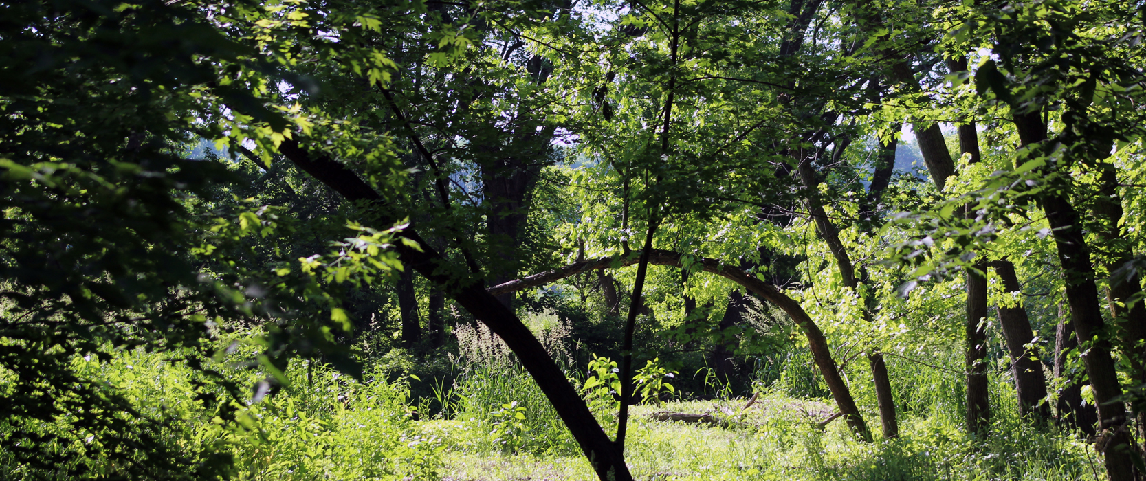
In amongst this 450+ acre streambank woodland corridor lives an abundance of animal and plant life. The Fourmile Creek Greenway consists of land that was previously developed for residential use. The area that was developed lies within a 500-year flood plain. With the purchase of this land, Polk County Conservation is restoring it to its natural landscape made up of native prairies, woodlands, savannas, and wetlands. Significant restoration work will began in 2020 and will take 5-7 years to complete.
Things to Do:
- Bird Watching
- Mushroom Hunting
- Controlled Bow Hunting
- Future Des Moines City Parks
- Future Central IA Water Trails Access
Visitors may collect the following for non-commercial use if the plant is not harmed:
- Nuts
- Fruit
- Edible mushrooms
Removing plants and cutting wood is illegal here.
Restoration of the Fourmile Creek Greenway
Fourmile Creek has been prone to flooding throughout its history. This has impacted countless residents, prompting evacuations and destruction to property. In order to minimize these impacts, extensive efforts have been taken by various city and county staff to remove at-risk houses and other structures from the floodplain.
In 2010, a Greenway Master Plan created a strategy for what to do with these now vacant parcels. This strategy outlined a plan to convert these areas to a more natural state, which would provide water quality and flood benefits. Polk County Conservation was selected to head this effort due to their experience and expertise. Almost all of the parcels bought out by the City of Des Moines in the lower portion of the Greenway have now been transferred to Polk County Conservation to complete restoration and management.
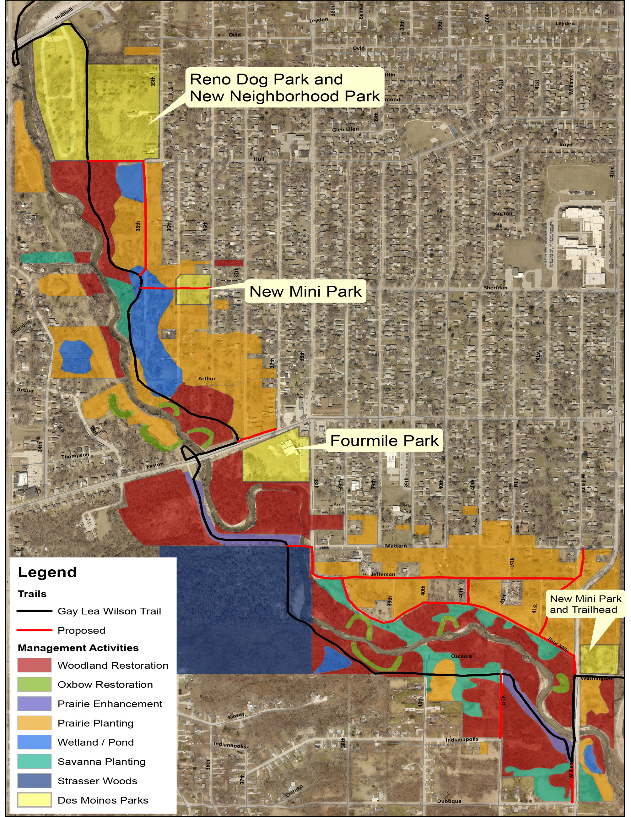
Restoration Plans
Polk County Conservation, and many other partners, plan to transform the Fourmile Creek Greenway to a corridor of natural areas that provides wildlife, water quality, and flood reduction benefits. This will create green space that will allow people to experience a serene, natural environment in the heart of Des Moines.
The current landscape is mainly turf grass left over from the many houses that once lined the streets. While turf grass may be better than concrete, it still does not provide many of the benefits listed above. Moving forward, these areas will be converted to native prairie, which provides all of these benefits and more. Along with the planting of native prairie plants, many other restoration techniques will be used in the Greenway. Below are some helpful definitions for the management activities referenced in the legend on the map on the opposite page.
Oxbow Restoration
An oxbow is a meander of a stream that has been cut off from the present flow of water. Over time, oxbows fill in with soil and lose the water quality improvement and flood reduction benefits they once had. Restoration of oxbows involves removing the soil that has built up in them over time and allowing them to fill with water once again. A connection to the current stream channel is also created allowing water to back up into the oxbow during large storm events. Oxbows also provide habitat for fish and wildlife.
Prairie Enhancement
Over time, areas planted with prairie can lose iversity and become dominated by just a few of the more aggressive native species instead of a wide variety of different plants. Prairie enhancement is completed by interseeding a diverse mix of native grasses and wildflowers native to central Iowa into the existing planting and mowing the area at regular intervals for several years. The increased diversity of the site will provide wildlife and water quality benefits.
Prairie Planting
Diverse mixtures of wildflowers and grasses native to central Iowa will be planted in open areas that have little tree cover. After seeding, these areas will be mowed 2-3 times during the growing season – for two years – to reduce weed pressure and provide light to the developing prairie seedlings until they become established.
Savanna Planting
Similar to prairie planting, but includes the planting of trees (typically oaks) to create a park-like appearance. Savanna is an ecosystem that is transitional between woodland and grassland (i.e. prairie). The widely-spaced trees allow the prairie plants to receive adequate sunlight and provide habitat for a unique suite of wildlife.
Wetland/Pond
Wetlands are shallow water (less than 4 feet) basins that typically have significant plant and animal communities associated with them. They provide opportunities for flood reduction, water quality improvements, and wildlife habitat. These sites shown on the map have been strategically sited to enhance their potential for flood reduction and water quality benefits. It is important to note that most of the sites shown on the map are tentative.
Woodland Restoration
Much of our woodland acreage in Iowa has been overtaken by invasive shrubs and trees. In addition, suppression of fire and other factors have favored the establishment of shade-tolerant species (e.g. elm, hackberry) to the detriment of more desirable species (e.g. oak, hickory). Restoration of these areas is important to help our native trees thrive and provide appropriate habitat for wildlife. Restoration will involve a process called Timber Stand Improvement (TSI) which includes removing invasive, less-desirable species and selective trees to create a more open understory.
Stream Restoration
Although not shown on the map, we expect to conduct extensive stream restoration projects on Fourmile Creek and its tributaries. Such work typically involves reconnecting the stream to its floodplain by flattening and widening stream banks. In-stream structures may be installed to prevent down cutting and to direct the current in ways which prevent bank scour. The result is a natural appearing and functioning stream that provides greater ecosystem services (e.g., flood mitigation, fish and wildlife habitat, recreation).
TIMELINE
Transforming the current landscape to a more natural state will take time. Converting turf grass to native prairie alone takes 3 to 5 years. Some work has already begun including oxbow restorations, construction of a storm water wetland, and prepping areas for prairie plantings to be established next spring. It is anticipated that major restoration work in the lower portions of the Fourmile Creek Greenway will be completed in 10 to 15 years.
ADDITIONAL INFORMATION

Bioblitz
Living with Natural Areas
Natural areas conserve and protect land to increase wildlife habitat, stabilize stream banks and introduce and maintain native woodlands and vegetation. It's different from a park because instead of having playgrounds, athletic fields, and irrigated turf, the focus is on conservation and preservation. Most natural areas also provide buffers between developed areas and floodplains offering protection to residential areas.
Do you live next to a natural area? View the helpful guide below that will help you better understand living with natural areas and what your role might be in your community.
Promoting land stewardship and sustainable watershed management that reduces flood risk, improves water quality, and supports socio-economic and environmental conditions.
The Fourmile Creek Watershed is 76,600-acres consisting of urban and agriculture communities. It is currently home to over 80,000 people. The watershed’s northernmost reaches begin near the town of Slater. The largest area of the watershed is located in Polk County and encompasses the cities of Sheldahl, Alleman, Elkhart, Ankeny, Bondurant, Altoona, Des Moines, and Pleasant Hill.
Fourmile Creek and its tributaries run for over 40 miles before draining into the Des Moines River. Along its path, the creek has a long history of extreme flooding, erosion, and poor water quality. To address these diverse issues, local communities created one of the first watershed management authorities in the state in 2012. This WMA focuses on collaborative work to address flooding and water quality.
Flooding
The primary focus within Fourmile Creek is to reduce flooding. With growing urban areas and increasingly common large storm events, flooding continues to cause damage in the watershed. To mitigate this damage, ongoing efforts focus on holding water in upland areas of the watershed, by utilizing practices such as regional detention basins and wetlands. Policy changes are recommended within urban areas of the watershed. Preserving stream buffers and floodplains protects urban residents and allows mother nature to function as intended.
Water Quality
Fourmile Creek has several water quality issues including excess nutrients, sedimentation, and bacteria. Across the watershed work must be completed in both urban and agricultural areas to improve water quality.
Watershed Areas of Focus
The Fourmile Creek Watershed is located in the Des Moines Lobe landform region, near the southern terminus of this lobe that formed during the Wisconsin Glaciation between 12,000 and 15,000 years ago. Glacial activity, other climatic events, and land use practices that followed the last glaciations have shaped the landscape, contributing to carving a more defined Fourmile Creek stream channel.
To address watershed issues, you must first understand what is happening within the watershed and creek. Key elements to understand include:
Watershed Management Plan
Fourmile Creek has a history of flooding that has impacted property owners in the watershed. Flooding is the major concern expressed by property owners and citizens. Although there has been minimal water monitoring data available until recent years, indicators have shown water quality should be an important element to address within the watershed. After community members expressed these concerns and jurisdictions desired to have a better collaboration mechanism, the Fourmile Creek Watershed Management Authority was formed to address these and other challenges.